
Photography at Fisher Towers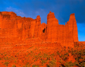 ,
Utah
This article
should be printed in landscape orientation.
,
Utah
This article
should be printed in landscape orientation.
Just to the North of Moab, Utah, lies one of the countries best scenic byways. It's known as Utah State Highway 128, running from Moab to near the uranium ghost town of Cisco. What makes this road unique is that it is the only highway to run next to the Colorado river, down inside the canyon. For those who don't want to hike down into the Grand Canyon to see what those cliffs look like from the bottom, driving 128 is the next best thing. Not as deep but still spectacular.
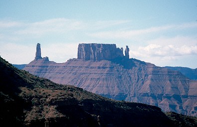
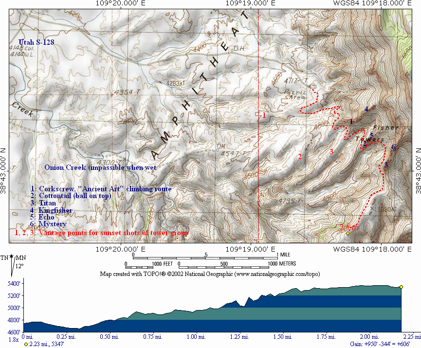
About halfway along 128 you'll see a sign to Fisher Towers. To the East you'll see a few low fins standing at the end of a vast butte. From the highway they don't look very interesting or even very photogenic. Take the road out there anyway. The magnificence of the Towers doesn't become fully apparent until you walk among them. The Towers lie at the end of a 2.5 miles rough but passable dirt road (the road does cross one wash, so don't try the road just after a big rainstorm). There is a small 5-site BLM campground at the end of the road ($10 per night, no reservations, vault toilet, no water) which is usually full during tourist-season weekends (you can find a spot if you get there by noon on Friday; weekdays you can find a spot easily). During the tolerably-cool Spring months, it is not uncommon to find the campground empty during the week, half-full during the weekend. Watch out for school holidays, which find the camp filled with college students from Colorado who come to climb the rocks. There is ample parking for day visitors (free). See the maps at the bottom of this page. If you can't find an open spot at the camp, look for a spot at one of the many BLM campgrounds near the Colorado River. If you don't want to camp, you'll need to stay at a hotel or motel in Moab, about a 40 minute drive. Fortunately, there isn't much here in the way of morning shots, so the driving delay isn't too painful.
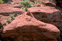
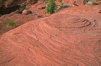
The Towers sit at the Southern edge of an unnamed mesa (well, it looks like a mesa, but really isn't--no cliffs on the eastern side; Fisher Mesa is located across the valley to the South). They are the last remnants of the same erosion process that created Bryce Canyon, and they might even be called hoodoos if they weren't so isolated and huge. The first thing you will notice is the brick-red color of the rocks. It's actually a soft sandstone (mudstone of the Cutler formation, capped by the harder Moenkopi formation). As you walk the trail, you'll find a lot of evidence of the speed of erosion: vertical mudstone walls, flowstone, and no desert varnish anywhere. Many scenes from the motion picture City Slickers II were shot at Fisher Towers.
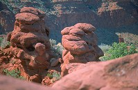
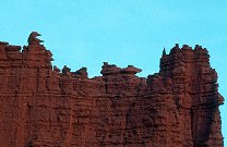
There are five main towers in the group, divided into three subgroups. (1) The Ancient Art/Corkscrew and Kingfisher (on the uphill side) group, (2) The Cottontail & Echo (on the uphill side) group, and (3) Titan.

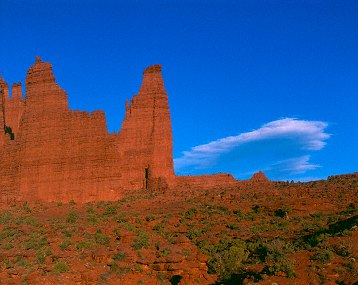
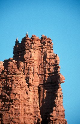
From the right-hand edge is Titan & Cottontail, the small
thin Corkscrew peak below, and then Echo. Kingfisher stands
the tallest here. Due to the
perspective, the dominant Titan
looks no taller
than the lesser towers. All photos are clickable. And yes, I know the colors on this are terrible.
You will find some good shots around the camping/parking area, especially of climbers practicing near camp for the longer routes on the towers themselves, or of the mesa at sunset. But all the best shots are out on the trail.
A climber practicing technique on a small rock
near camp. Kingfisher Tower in the background/
A morning shot from just down the trail, using the blue
skylight and reddish rock to create a unique color effect.
The rock is about 1/2 to 2/3 stop underexposed to enrich color.
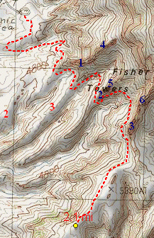
The Tower Trail, 2.1 miles long, 600 ft
total
elevation gain, +1000 ft & -400 ft net.
The tower trail is well groomed and considered moderately strenuous. Most of the trail isn't bad at all, but there are a couple very steep switchback sections near the start that will really strain even the most fit of us carrying photographic equipment. Just take your time on those sections, and make sure you bring some water along. Just be satisfied that it will all be the easier on the trip back. Unburdened it takes about 60 - 90 minutes moving directly out to the end of the trail, which is just over two miles long. If you carry a camera, however, you'll end up taking much longer as you grab shots all the way there (and even more shots coming back).
Just after the trail passes the back side of Cottontail, as it turns out to its final destination, there is a wash that can be difficult to cross. The trail construction team has (or rather had) placed a heavy metal ladder to assist hikers through the wash, but the spring rains of 2002 washed it so far down the canyon (as it does every year) that this year it wasn't found. Officially this year the trail closes at the wash, but if you are nimble and have a partner to assist with the gear it can be crossed. Fortunately, most of the best shots are found before this wash. [Note: this information is based on my last visit in late June, 2002. Things might have changed since.]
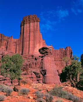
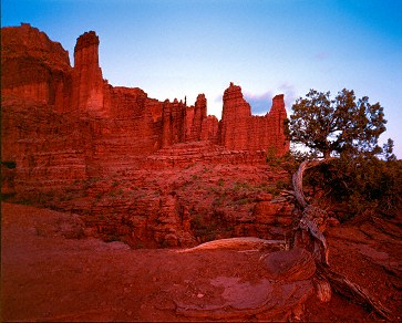
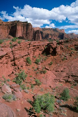
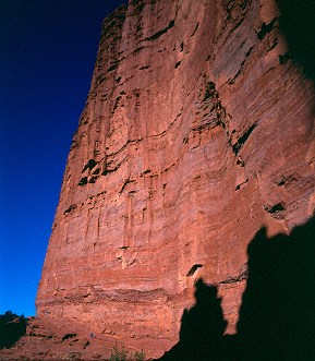
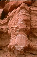
I need to explain something about the rock here, something you've probably noticed in the first few shots I've used on this page. The sandstone is filled with quartzite with high reflectivity. If the light is well-aligned with the viewer, it has a remarkable ability to reflect the incident light, and will glow a brilliant orange in the low-angle light of sunset. But if the light is perpendicular to the viewer, the rock darkens and turns the brick-red you see in the second and third shots. And due to the high color of the rock, any green vegetation, especially the old juniper trees, takes on an almost neon appearance once your eyes have become accustomed to the red color (green being approximately the compliment of the red color of the rock). It's a very eye-catching effect to observe, but film, lacking the color acclimatization ability of the eye, will not capture this effect. Digital might if you set the white balance using the rock, rendering the rock as gray and the foliage that neon green. Depending on the direction of light and the nature of your color film, the rock can look brick red, through pink, to brilliant orange.
Group Shots
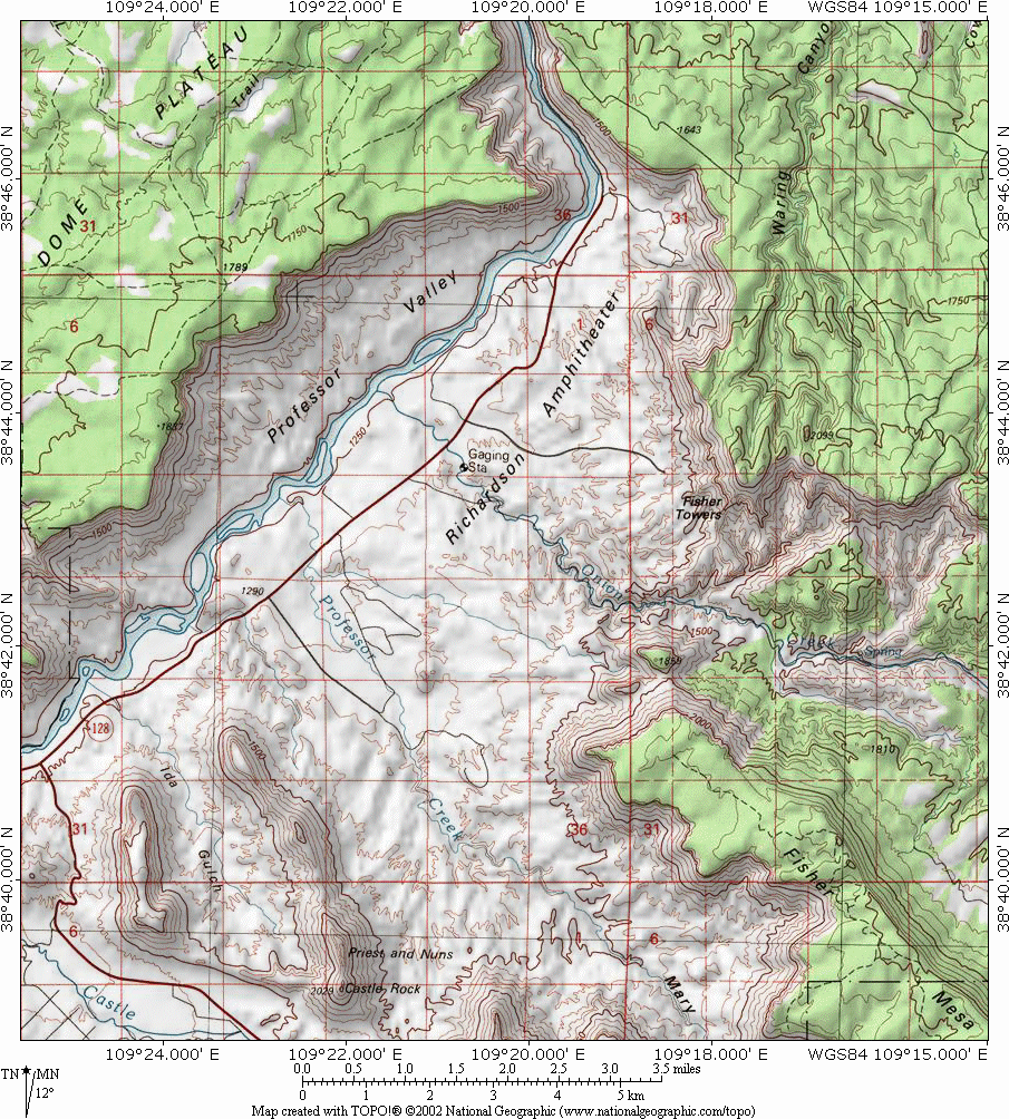
There are several sorts of shots out on the trail. The group shots, where you capture more than one of the towers, is difficult to shoot from the trail itself, due to the size of the towers and the proximity of the trail (not even fisheye lenses will get the towers from top to bottom when the trail runs right along the base of the tower). Fortunately there are several moraines that provide excellent vantages of the tower groups. They are noted on the map below in red.
Caviat: Please, please, please remember that if you venture off trail, you are responsible for both your own safety and the safety of the life your are stepping on. The most fundamental form of life in the desert southwest is called cryptobiotic soil. It is soil stabilized by a symbiotic colony of lichen (which is itself composed of fungus and algae) and bacteria. "Crypto", as it's known, is extraordinarily fragile, and one step will kill it for a decade. But it is the only thing that stabilizes and enriches the soil enough to allow anything else to grow, and must be preserved. If you do venture off trail, make very sure you can recognize patches of crytpo and make every effort to avoid treading on it. The safest plan: walk only on hard rock. Crypto is generally seen an a bumpy, dark patch of soil, but early formations of crypto lack the darker color of the old patches. Drive the Castle Valley Road (you passed the turnoff on the way from Moab) and you'll see lots of it as you enter the section of rolling hills before the first big turn to the South.
Note the compression artifacts you can encounter in
rendering your
images for the web: .jps's don't like
red/blue contrast,
and many sunset shots will have a lot.
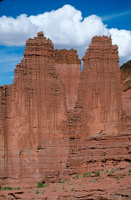
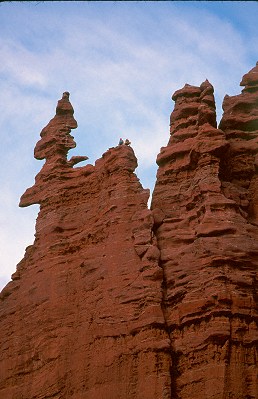
Shot from position #3. Cottontail and Titan.
The red #1 in the trail map I've provided (bottom of page) is the easiest to reach, and the #2 & #3 spots are the hardest. Unfortunately, the #3 spot offers the best view and angle on the towers, and it's worth the effort to get out there. The #2 spot is good if you want foreground detail. If you don't want to walk all the way out to the #2 I've indicated, go out on the bench the branches off it, and there are plenty of good locations as you walk down the moraine. Start about 1.5 hours before sunset to be in position with plenty of time. Don't waste film! There are a lot of good shots to be had in the 30 minutes that follow the sunset itself, so remain out there until it begins to get too dark to shoot. One nice sunset effect is the shadow of Dome Mesa (to the West) moving up the towers until the tall spire of Titan is the last to hold the sun; it's a nice way to show its height without hiking to the end of the trail. Remember to apply film recipricosity corrections in the low light. It's also good to have something like a Petzel LED headlamp to help get you back to camp in the low light.
One thing you'll need to watch for in the wide shots is condensation trails from jet liners passing overhead. The Fisher Towers area sits directly under a very busy high-altitude jetway (From Grand Junction CO to Milford UT; carries DEN to SFO traffic), and if the sky has those thin high-altitude clouds that make the sky so interesting, it will hold onto the contrails too.
As you hike the trail, you will cross a lot of slickrock. Watch for the small piles of rocks, cairns, which mark the trail.
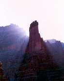
Exposure: For daytime shots putting the rocks on zone 5 or 4.5 (0 or -1.2 stop EV) will get a nice rendering of the rock color and sky. The green foliage of the junipers is about 1/2 stop under the brightness of the rock, so it comes out pretty well in the EV 0 shots. One problem with this location is in the late evening the light is so flat that much of the relief detail is lost, leaving the towers looking rather blank (see the first image on the page, where I put the rock on Zone 6 and washed out much of the detail that was visible--the clouds were about 1.5 stops under the rock, and I thought I could get away with it). Sometimes this shot works better if you can find a position that is not in direct line of the sunset, maybe a 20-30 degree angle. Normally I expose sunlit red-rock in zone 6 (one stop overexposed from a meter reading on well-lit rock). But late in the day, in the flat light of sunset, putting the rock right on zone 5 is best to bring out both the rich color and relief detail.

A shot of the Corkscrew and Cottontail, with Titan peeking out from
behind, from just off the trail (heading toward position 2). Note
the scale of the several hikers wearing white.

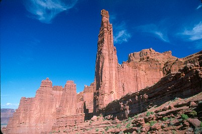
From near position #3, where Titan is easily separated
from the other towers. Old, weathered junipers are easy
to find off the trail, and make good foreground elements.
You might also pay particular attention to those days of the month when the moon is approaching full (waxing). That's when the moon comes up far enough to include in your tower sunset shots. The waning moon comes up well after the light is gone.
The other good group shot is from the far terminus of the trail. It's a grand view out there, one that works best in the morning, the earlier the better. Unfortunately, due to the remoteness of the location, sunrise shots from this location are difficult to get. The trail is about 1.5 to 2.5 hours long (laden), which means that to be at the trail end at sunrise (6 a.m. in summer) means departing between 3 and 4 a.m. I've never done it, so I don't know what sort of shadows the very tall Titan throws on the others at first light. Judging by the geometry of the towers indicated on the topo map, I'd guess that the sunrise shot is doable in winter, but not in summer when the sun rises at a high latitude. If you are keen to get up that early, why not try for some star trail shots with a tower silhouette in the foreground?
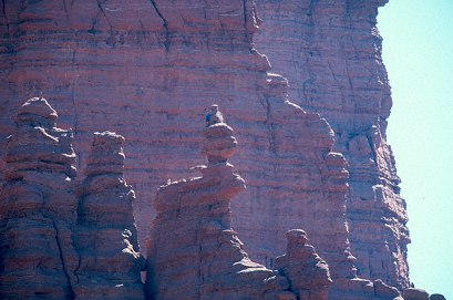
Shots of the tower group from near the end of the trail, at about 10 a.m.
On
the left is Cottontail and several
other towers. The leftmost image
shows Cottontail and Echo Towers,
with Kingfisher behind. The image on
the right shows the predominance of Titan in relation
to the rest of the towers.
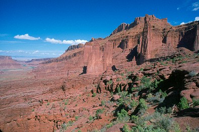
A wide shot from the far end of the trail. Note the position of
the towers in relation to the mesa. To the left you can see the
parking lot, and the gentle curves of the Colorado river as it
enters Professor Valley. A long lens can do some good things here.
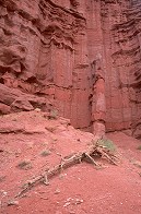
Other interesting groups from out on the trail are the nearby Castle Rock (a.k.a. Castleton Tower) and the Rectory, Priest and Nuns. Castle Rock makes some good shots on its own, and the trail out is easily accessed from the Castle Valley road (look for a very dusty parking and camping area with a view of the tower down a small canyon).
Castle Rock, The Rectory, and Priest and Nuns.
Fisher Mesa is in the foreground when shot from the trail end.
From the end of the trail there are also some good vistas of the Eastern side of the towers area, the one that is accessible only with much difficulty (there is no trail beyond the tower trail, but if you climb or scramble I think you can get out there; you're on your own with little chance of rescue should you become immobile).
The inaccessible area beyond the Towers.
Details from Out on the Trail
When you are hiking the trail itself, abandon hope for many tower group shots. The trail winds among the towers, sometimes at the very base of the vertical walls, and trying to get the entire tower from its base is not possible. I've found many detail shots, though. The junipers of the area are all quite old (thanks to there not being a fire through the area in anyone's recollection), and in age they have gained personality. They make excellent foreground objects, as do the weathered rock formations.
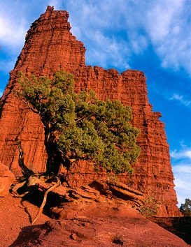
Juniper and Cottontail, late afternoon.
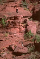
It is in the detail shots that you can give viewers of your photographs some idea of the magnitude of this place. Having someone on the trail helps establish scale.
The trail along the Eastern base of Cottontail.
Click on the image and find the hiker.
About 11 a.m. Notice the tall towers are
still casting shadows well into the day.
It is in the detail shots that you can capture one of the most amazing aspects of Fisher Towers: the other-worldly feel of the place. There is literally no other place on earth like this. The rocks are very striated (layered), the dirt is either orange or brick-red, the green, as I said earlier, stands out brightly. The combination has a magical quality, and when you are surrounded by the enormous towers too, it really is an amazing experience, one that is difficult to capture on film.
Other shots in the morning you might want to try are the backlit shots, especially if there is much haze in the air.
One other shot of the Towers you might want to try is a location on the Colorado river itself, looking South down the valley using a long lens. The spot is just past the bend at the top of the map below. It's a good sunset shot.
Climbers
You can also get a lot of good shots of the rock climbers that haunt the rocks. Don't worry, if you want to shoot a tower and a climber is there you'll never see him. But there is one route, the "Stolen Chimney" route up the edge of Ancient Art, that is considered one of the ten best climbing routes in the US. Weekends will always find at least one group in the route, and frequently there will be several groups waiting. Shooting from below with a long lens, from the opposite slope, and even from the parking lot will yield some interesting shots. Things to watch for: the "sidewalk", the horizontal section near the corkscrew and diving board which narrows to 8 inches wide with 400 foot drop-offs, is something of a test of fear to walk--not crawl--this section. Also, watch how they get onto the diving board. The classic method is to belly flop onto the end (they call it 'mantling'), with some risk of falling over the side, so many will just climb up over the base.
Climber topping out on Echo (next to
Cottontail), shot from the campground
with a 200mm lens and 2x extender.
Nearing the Corkscrew, the top of the "Stolen Chimney" route.
The horizontal protrusion is called the Diving Board.
Shot from the parking lot, a climber nears the top of the Corkscrew.
I hope this article gives you an idea of the beauty, magnificence, and hugeness of the Fisher Towers area. Have fun shooting there!
These maps are clickable:
Links
Climbing Kingfisher, Ancient Art, Titan,
Pictures by Utah Pictures, Utah Canyon Country