
This is a guide to photography in the San Rafael Swell. Particularly, the half of the Swell North of Interstate 70. A guide to the southern half will likely follow in 2005.
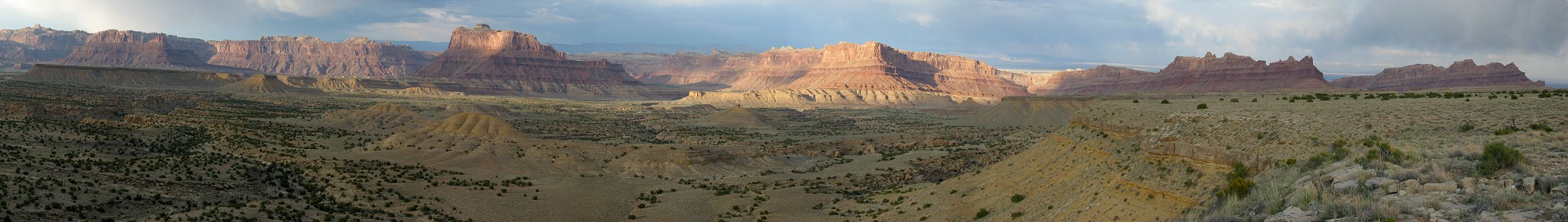
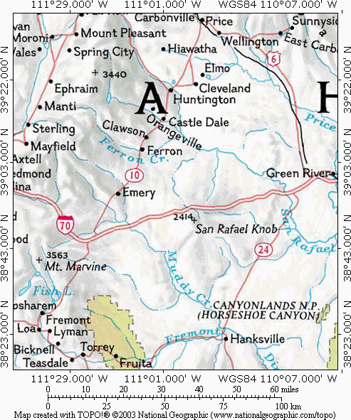
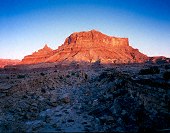
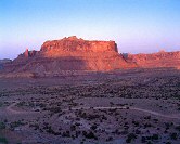
The Swell is a geological uplift in central Utah. It is roughly kidney shaped, and is ringed by the towns of Price, Green River, Hanksville, Cainsville, the northern part of Capitol Reef National Park, Fish Lake National Forest, Emery, Castle Dale, Huntington, and Cleveland (map). In all about 60 miles long and 30 miles wide. The uplift, in this case, is a non-symmetrical dome of rock pushed up by great pressures below over the space of millions of years. During the uplift process, much of the rock was eroded away, leaving some beautifully varied and exposed layers. Since the east side formed a steep slope, it has eroded into a reef, white Navajo sandstone visible from the east, and red Wingate cliffs from the west. Here are the tall red cliffs for which the Colorado Plateau is known, old limestone buttes, and stretches of sandy desert. The bulk of Utah's red cliff canyons are found southward in the Colorado Plateau, a huge uplift covering four states, and is the home of some of the nation's most scenic red-rock national parks: Zion's, Bryce, Arches, Canyonlands, and Grand Canyon, to name a few. The San Rafael Swell is the only other place you can see these formations exposed.
Human History
 There is no
permanent human settlement in the Swell, nor has there ever been.
Wilsonville
was the first settlement in the area (founded by my Great-Great Grandfather; see
the historical article by my father by clicking the link above). It was located a couple miles southeast of
what is now Castle Dale. It's gone now, but the other towns in the area, like
Wilsonville, exist only at the more habitable periphery of the Swell. There have always
been,
it seems, a few livestock men in the Swell itself, but never permanently.
Mexican Mountain is named for a shepherd of Mexican descent, and many geological
features are names after one of the Swazy (a.k.a. Swazey or Swayze) brothers (Joe and his Dog, Swazy's Leap,
Sids Hole, etc.), who
made a living either gathering wild horses to sell to the army or by running cattle.
Currently no one lives in the Swell longer than the rangers at Goblin Valley
State Park, and even they are just outside the Reef.
There is no
permanent human settlement in the Swell, nor has there ever been.
Wilsonville
was the first settlement in the area (founded by my Great-Great Grandfather; see
the historical article by my father by clicking the link above). It was located a couple miles southeast of
what is now Castle Dale. It's gone now, but the other towns in the area, like
Wilsonville, exist only at the more habitable periphery of the Swell. There have always
been,
it seems, a few livestock men in the Swell itself, but never permanently.
Mexican Mountain is named for a shepherd of Mexican descent, and many geological
features are names after one of the Swazy (a.k.a. Swazey or Swayze) brothers (Joe and his Dog, Swazy's Leap,
Sids Hole, etc.), who
made a living either gathering wild horses to sell to the army or by running cattle.
Currently no one lives in the Swell longer than the rangers at Goblin Valley
State Park, and even they are just outside the Reef.
As you travel through the area you will find evidence of the only people to have halfway managed a living in the Swell: the Barrier and Desert Cultures, then the Fremont, then the Ute and Paiute cultures. All were migratory, and stayed in the Swell only part of each year. I highly recommend a visit to the Museum of the San Rafael (Castle Dale) to see some artifacts these people left in the Swell. And of course you'll be seeing some of the abundant rock art they have left us.
Lodging
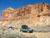 I always camp in the Swell. The most obvious camp is the Bridge campground,
a BLM-operated, 12-site waterless camp. It's a Spartan place to camp, each site
having only a table, a fire pit, and some having a tent pad, with a community
vault toilet, but it is only $6 per day, not bad for the price. Since the Swell
is so big, I've also camped in many other locations (always trying to practice
Leave No Trace ethics): on the Wedge
overlook, under the cottonwoods near the river along Mexican Mountain road, in
the juniper atop Cedar Mountain. You can also camp along the road to the Jackass
Benches. It's all primitive camping, with absolutely no facilities. Try to camp
in established sites. Amazingly, for an undeveloped area, there are six
public toilets in the
northern part of the Swell: at the Wedge overlook, at the Cedar Mountain picnic
area, midway down Buckhorn Wash, at the Buckhorn pictograph panel, at the Bridge
campground, and at Swazy's cabin.
I always camp in the Swell. The most obvious camp is the Bridge campground,
a BLM-operated, 12-site waterless camp. It's a Spartan place to camp, each site
having only a table, a fire pit, and some having a tent pad, with a community
vault toilet, but it is only $6 per day, not bad for the price. Since the Swell
is so big, I've also camped in many other locations (always trying to practice
Leave No Trace ethics): on the Wedge
overlook, under the cottonwoods near the river along Mexican Mountain road, in
the juniper atop Cedar Mountain. You can also camp along the road to the Jackass
Benches. It's all primitive camping, with absolutely no facilities. Try to camp
in established sites. Amazingly, for an undeveloped area, there are six
public toilets in the
northern part of the Swell: at the Wedge overlook, at the Cedar Mountain picnic
area, midway down Buckhorn Wash, at the Buckhorn pictograph panel, at the Bridge
campground, and at Swazy's cabin.
If you are not a camper, there are small towns with good lodging near the main access roads into the area: Green River (for access via I-70), Castle Dale (for access from the west), and Price (for access from the north). Lodging in the town has the drawback of adding at least an hour to your morning drive times, and the benefit of not camping in the dust and biting gnats. Oh, the gnats. They come out in April, and stay 'till about July. They are the only real pest in the Swell, and I frequently visit the area in winter just to avoid them.
There is no drinking water available anywhere in the Swell. Bring your own, and bring lots. I bring at least a gallon a day, plus three to spare. Bring two gallons a day in the hot summer months. If you plan to use water from the San Rafael River or from Sid's Hole (the only water you can find in summer) you'll need to purify it. It isn't too dirty, but is is downstream from some pastures
Roads
All roads in the Swell, except for I-70, are dirt. The more trafficked roads are bladed a couple times a year, and Spring 2003 the road from Castle Dale to the Bridge, and roads to the north and south of the Well were oiled (to keep the dust down). But even the better-maintained roads are still hard on tires and your car. Most of the locations I refer to can be accessed in a passenger car, and I will note on the maps or in the text which roads will require an SUV, and which need a jeep or ATV to travel. But please note that a good and careful driver can take a passenger car on a road I'll label for SUV's, or can take an SUV down a road I'll label for jeeps. I drive a Subaru Forester (compact SUV) and an Honda Rincon (4WD ATV), which I've used to "calibrate" my road standards.
I do have one thing to say about wet roads: AVOID THEM! The dry desert will soak up light rain without wetting the ground at all. But on occasion a rainstorm will wet the roads, especially late summer. In winter the snowmelt can also turn the surface of the roads into mud. The mud is slick and sticky. It is difficult to drive in, leaves ruts in the road, and it will probably never come off your car completely. I drove in light mud once, and two months later, after repeated pressure washes, the mud I collected that day is still falling out of the suspension.
But of more immediate concern in a rainstorm is flash flooding in the valleys. The roads in the Swell cross many dry washes that can flash flood in a good storm. Flash floods, bringing water down from the plateaus above, might bear car-sized boulders and can appear before or after local rainfall. I always carry a few days food and water in the car when I'm away from camp in case I get stuck out some place because of the rain. It's better to wait a few days where you are than risk slipping into a gully hurrying back to town. You'd still have to wait, only sideways, half buried in mud.
To drive in the Swell you should have maps. The best maps to have are the National Geographic/Trails Illustrated map of the San Rafael Swell (map # 712), and the BLM February 2003 Vehicle Access Map (I got mine from the brochure kiosk at the Museum of the San Rafael in Castle Dale). Large maps of the area, like travel maps or the Delorme and Benchmark State map books, are useless for navigation. I also use the National Geographic Topo! maps of Utah for reference and for map display in the article. And of course a good GPS unit with topo maps is invaluable.
The Castle Dale Road/Green River Cutoff
 I've
always enjoyed the 20 mile drive into the Swell from Castle Dale. The turnoff
from highway 10 is barren, but there is a photogenic old corral
complex there. As you drive in you pass over the Blue Gate shale, past the gray
Tununk shale cliffs, past the colorful Morrison and Cedar Mountain formations
(made of decomposed volcanic ash, maroon, blue, green, much like the Bentonite
Hills to the south of the Swell), it's like driving through another land. I
think it's this entrance that best introduces the Swell. The passage
through this surreal landscape clears the palate, one might say, for the
grandeur that is coming. As the high cliffs of Cedar Mountain come into view,
you'll pass geological features that have been navigation points for centuries:
the White Rocks, the Red Knoll, and the Buckhorn Flats Well. The Red Knoll is a butte-like outcropping of Entrada sandstone that was sufficiently
capped by Curtis formation conglomerate to protect it from erosion. Just past
the cattle guard you can drive south to a very nice alcove of Entrada sandstone.
While not as interesting as the hoodoos of Goblin Valley (same rock layer,
different erosion process), it is a fun place to explore and shoot. Just beyond
the Red Knoll is the great intersection in Buckhorn flat, a central landmark of
the northernmost part of the Swell. Here roads lead to the Wedge and the Red
Ledges (south), to Cedar Mountain (north), to the Buckhorn Draw (east), and to
the Green River Cutoff (also east). And of course Castle Dale (west).
I've
always enjoyed the 20 mile drive into the Swell from Castle Dale. The turnoff
from highway 10 is barren, but there is a photogenic old corral
complex there. As you drive in you pass over the Blue Gate shale, past the gray
Tununk shale cliffs, past the colorful Morrison and Cedar Mountain formations
(made of decomposed volcanic ash, maroon, blue, green, much like the Bentonite
Hills to the south of the Swell), it's like driving through another land. I
think it's this entrance that best introduces the Swell. The passage
through this surreal landscape clears the palate, one might say, for the
grandeur that is coming. As the high cliffs of Cedar Mountain come into view,
you'll pass geological features that have been navigation points for centuries:
the White Rocks, the Red Knoll, and the Buckhorn Flats Well. The Red Knoll is a butte-like outcropping of Entrada sandstone that was sufficiently
capped by Curtis formation conglomerate to protect it from erosion. Just past
the cattle guard you can drive south to a very nice alcove of Entrada sandstone.
While not as interesting as the hoodoos of Goblin Valley (same rock layer,
different erosion process), it is a fun place to explore and shoot. Just beyond
the Red Knoll is the great intersection in Buckhorn flat, a central landmark of
the northernmost part of the Swell. Here roads lead to the Wedge and the Red
Ledges (south), to Cedar Mountain (north), to the Buckhorn Draw (east), and to
the Green River Cutoff (also east). And of course Castle Dale (west).
 Before I-70 was put through the Green River Cutoff was the main road between Green River and
Castle Dale. The western part of the road is now the most traveled road in the
Swell (apart from I-70) and is well-maintained. As you continue east to Highway 6 the
road gets narrower, more rocky, and frankly more interesting. You'll pass by the
old railroad grade that was going to be the main Union Pacific line through Utah
(it was abandoned before any rail was laid, the bosses preferring a direct route
through Price then over Soldier Summit to Spanish Fork). You'll also pass some
parts of the Old Spanish Trail, but I've never found the Trail itself particularly
interesting. Farther east the road passes through the Entrada formations and
some pleasantly-rounded conglomerate formations on the twisty road.
Before I-70 was put through the Green River Cutoff was the main road between Green River and
Castle Dale. The western part of the road is now the most traveled road in the
Swell (apart from I-70) and is well-maintained. As you continue east to Highway 6 the
road gets narrower, more rocky, and frankly more interesting. You'll pass by the
old railroad grade that was going to be the main Union Pacific line through Utah
(it was abandoned before any rail was laid, the bosses preferring a direct route
through Price then over Soldier Summit to Spanish Fork). You'll also pass some
parts of the Old Spanish Trail, but I've never found the Trail itself particularly
interesting. Farther east the road passes through the Entrada formations and
some pleasantly-rounded conglomerate formations on the twisty road.
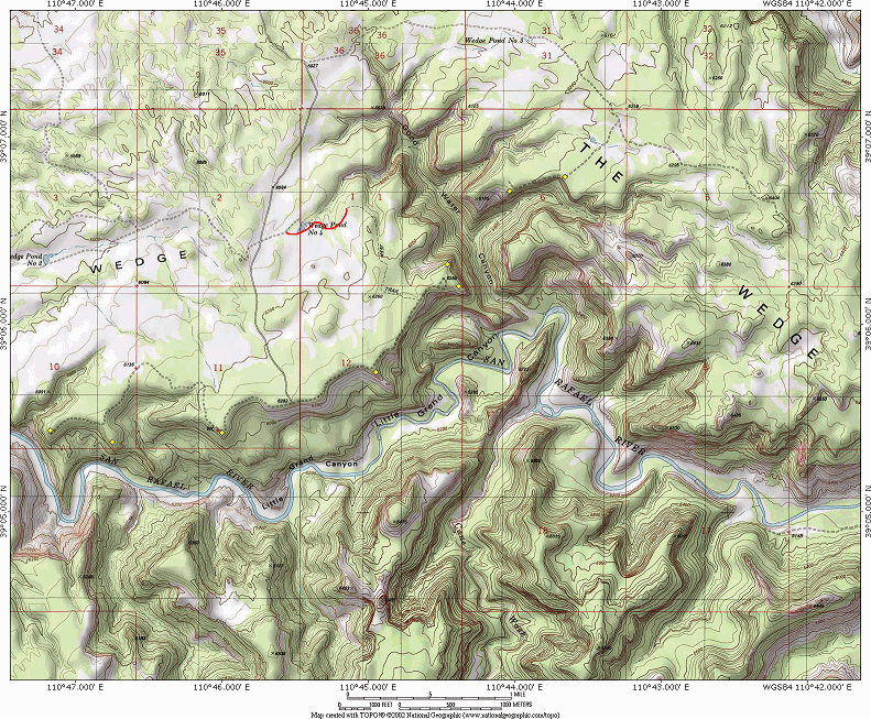
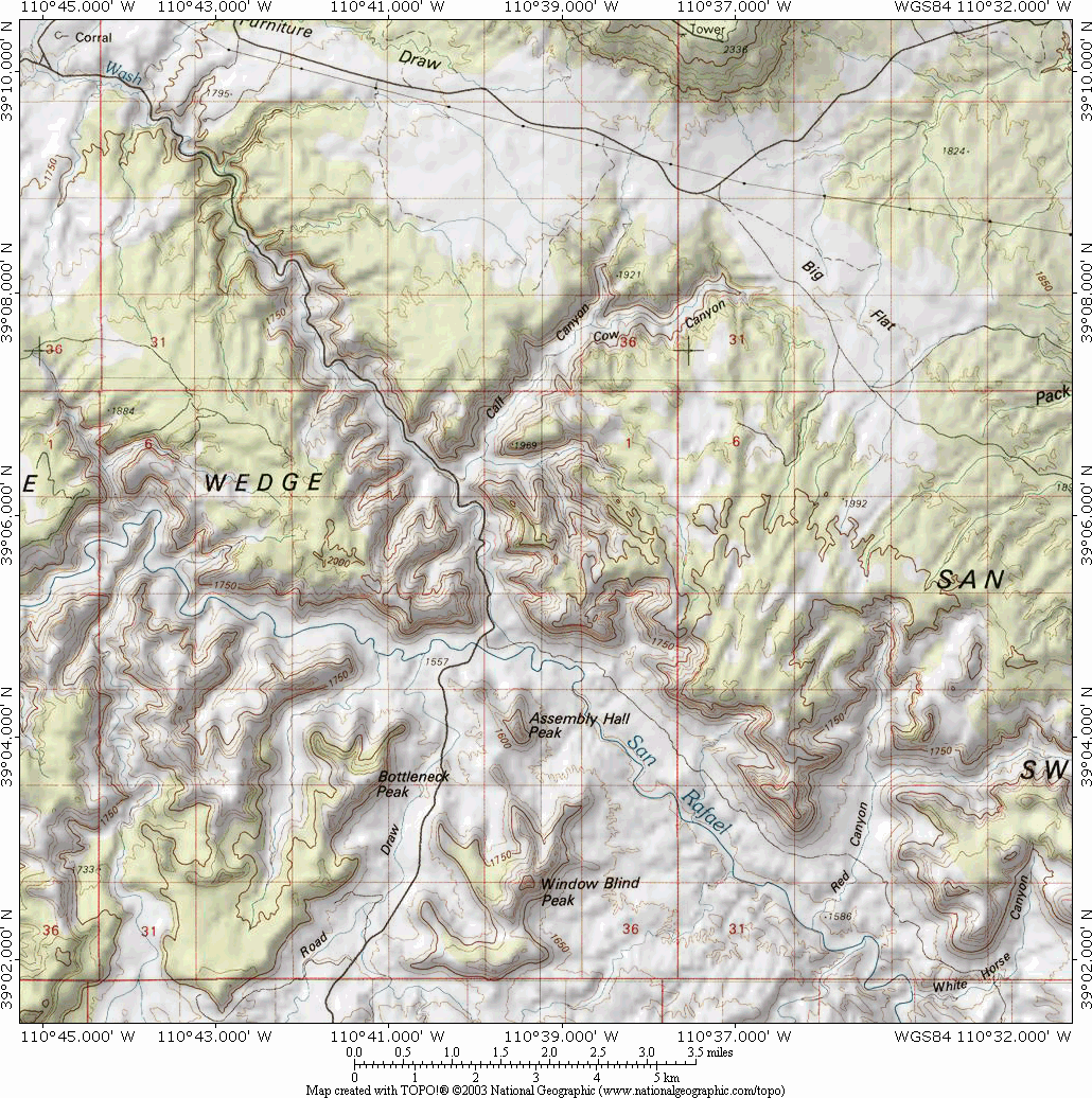
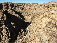
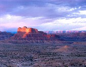
The Wedge
 One of the three most popular places in the Swell (the others being Goblin
Valley and the Buckhorn pictograph panel), the Wedge overlooks the Little Grand
Canyon of the San Rafael River (map). Coming in from any direction the turnoff is
that
famous human landmark in the northern Swell: the Buckhorn Flats Well. My father says
that you can drink the water from that well, but you must avoid any sudden
movements for a few days afterwards. The pump is in the small building.
One of the three most popular places in the Swell (the others being Goblin
Valley and the Buckhorn pictograph panel), the Wedge overlooks the Little Grand
Canyon of the San Rafael River (map). Coming in from any direction the turnoff is
that
famous human landmark in the northern Swell: the Buckhorn Flats Well. My father says
that you can drink the water from that well, but you must avoid any sudden
movements for a few days afterwards. The pump is in the small building.
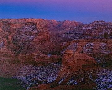
 The
wedge overlooks the Little Grand Canyon. The best light for the Little Grand
Canyon is in the summer, when the sun rises northerly enough to illuminate
the far slopes and ridges opposite the overlook. I think the best viewpoints
are on the east side of the Wedge. There is a nice long outcrop midway
along, and a very nice view from the most eastern point. In winter the sun
rises right up the San Rafael River valley to the southeast. When the sun shines on the rim of the canyon, there is a serious contrast
issue that is solved only through digital techniques, or by pulling the film
during development. If you expose for the lit rock, shadows will drop into
blackness; expose for shadows, and the rims are blown out. I prefer the
minutes just before the sun rises, and just after the sun sets, when the
light is still directional and colored, but much flatter.
The
wedge overlooks the Little Grand Canyon. The best light for the Little Grand
Canyon is in the summer, when the sun rises northerly enough to illuminate
the far slopes and ridges opposite the overlook. I think the best viewpoints
are on the east side of the Wedge. There is a nice long outcrop midway
along, and a very nice view from the most eastern point. In winter the sun
rises right up the San Rafael River valley to the southeast. When the sun shines on the rim of the canyon, there is a serious contrast
issue that is solved only through digital techniques, or by pulling the film
during development. If you expose for the lit rock, shadows will drop into
blackness; expose for shadows, and the rims are blown out. I prefer the
minutes just before the sun rises, and just after the sun sets, when the
light is still directional and colored, but much flatter.
If you continue around the rim road to the east you'll find another point (facing the northeast) with some nice mid-morning shots of Good Water Canyon with great foreground rock formations. If you have a 4WD, there is a fun jeep trail (suitable for any SUV) that leads through seemingly virgin plateau. There I've seen the best patches of crypto in Utah; watch your step, please. The trail continues back to the road leading to the Wedge from Buckhorn Flats.
There are overlook points on the west side of the
Wedge, but I've never had much luck there. There are a few campers here on a typical weekend.
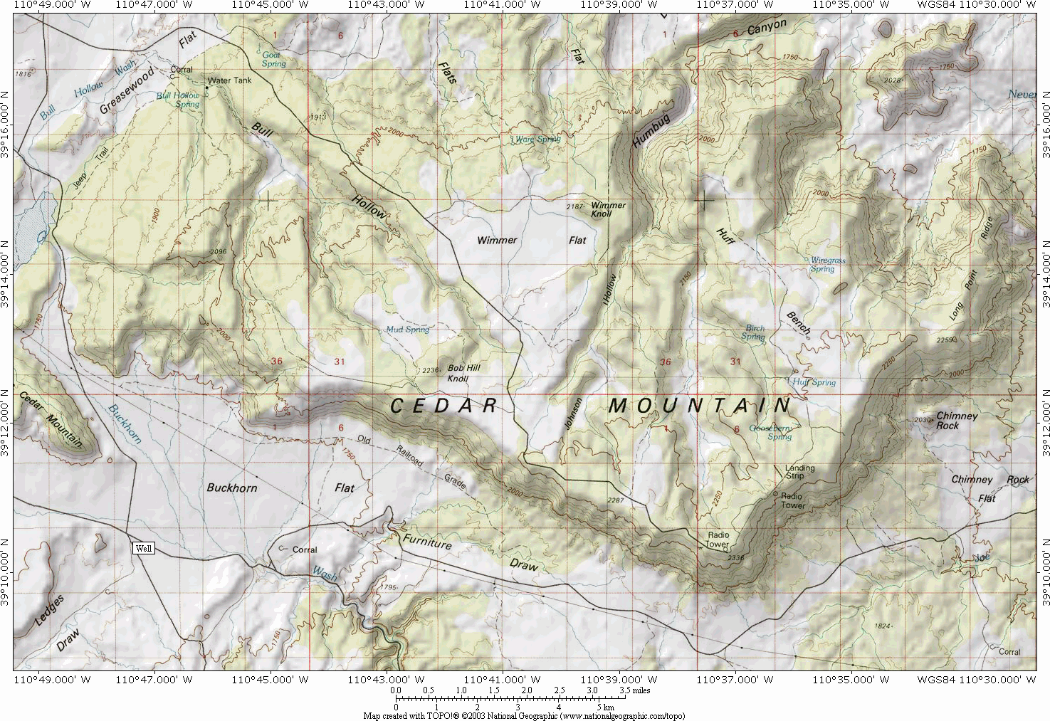
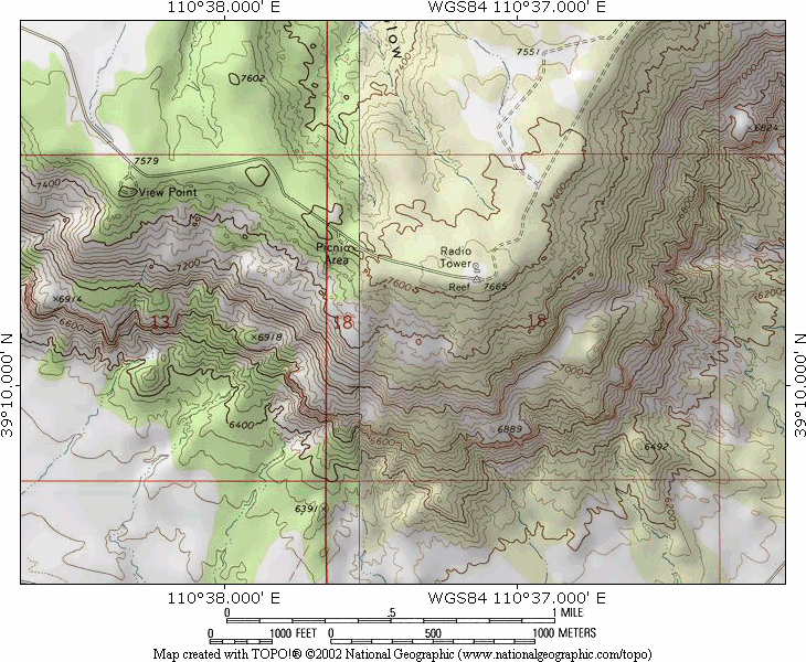
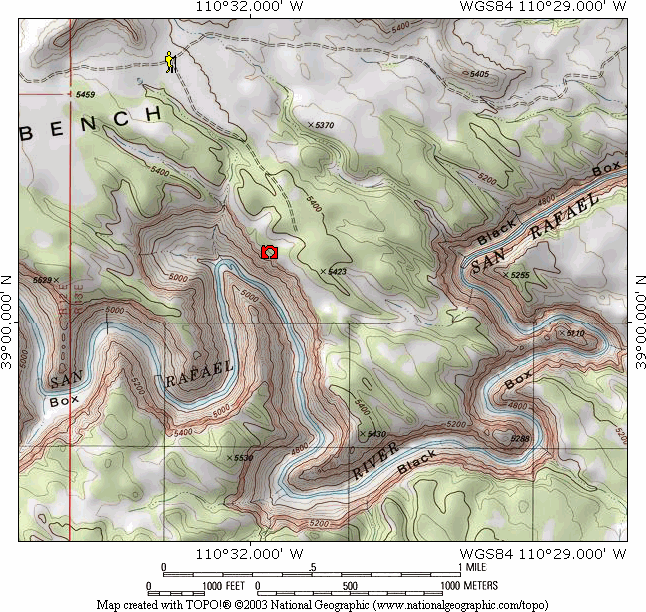
Cedar Mountain
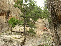
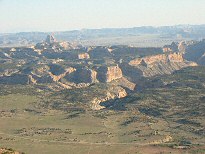 Cedar mountain is 1500 feet above the Wedge plateau, but
it provides a grand overlook of the entire northern Swell (map). Getting to the top of
Cedar Mountain from the Wedge takes 45 minutes to an hour, as you need to drive
to the north side of the wedge-shaped mountain, though it's only nine miles away
as the crow flies. There is a recreational site at the top of the mountain, an
overlook and a picnic area. The picnic area has better facilities, with ten
or so tables and informational plaques at the well-built overlook.
Unfortunately, the eastern view of the swell is blocked by higher parts of the
mountain. Kids have a blast here, if your family is along. There are some nature
trails here also.
Cedar mountain is 1500 feet above the Wedge plateau, but
it provides a grand overlook of the entire northern Swell (map). Getting to the top of
Cedar Mountain from the Wedge takes 45 minutes to an hour, as you need to drive
to the north side of the wedge-shaped mountain, though it's only nine miles away
as the crow flies. There is a recreational site at the top of the mountain, an
overlook and a picnic area. The picnic area has better facilities, with ten
or so tables and informational plaques at the well-built overlook.
Unfortunately, the eastern view of the swell is blocked by higher parts of the
mountain. Kids have a blast here, if your family is along. There are some nature
trails here also.
The best overlook of the Swell is up by the antennas (map). If you look for a small brown building on the right of the road, you'll find a driveway just west. Park on the main road (so as not to park on the ground wires running across the driveway) and walk south directly toward the edge. You'll find a nice flat rock with a view of the Swell in it's entirety, but because of some electric wires to the east, shots of the Book and Roan Cliffs are less than optimal. Views of the Swell with a wide-angle lens (you'll need at least a 24mm to get it, but a 20mm lens is better; it's definitely a panoramic shot) will include a sweeping bit of the Green River Cutoff road below, but it isn't unsightly unless there is traffic kicking up dust. If you want some foreground juniper and conglomerate rocks, there is a location farther on, at the southeast point that will provide some opportunities if you search.
The road continues around the eastern side of the mountain (SUV or jeep) for a top-down view of Chimney Rock and unobstructed views of the Book and Roan Cliffs on the eastern horizon. Look for a north-going road about halfway down the wide dirt runway, then look for a trail going east about 1 mile along.
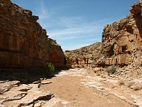
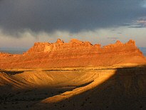
Buckhorn Draw
 This is the second most popular
spot in the Swell, and for good reason. The Draw was cut by the creek running
down the canyon before Buckhorn Reservoir was put in (map). It's remarkable for its
geology, cutting down through the Navajo, Kayenta, Wingate, Chinle, and Moenkopi
sandstone formations, the strata known as the Glen Canyon Group for which the Colorado
Plateau is so well known. Partway down the Draw are the Cow and Calf canyons,
both prominently visible from Cedar Mountain. Here is a short list of some of
the things to look for as you descend from the Buckhorn Draw turnoff, or from
the Bridge coming up:
This is the second most popular
spot in the Swell, and for good reason. The Draw was cut by the creek running
down the canyon before Buckhorn Reservoir was put in (map). It's remarkable for its
geology, cutting down through the Navajo, Kayenta, Wingate, Chinle, and Moenkopi
sandstone formations, the strata known as the Glen Canyon Group for which the Colorado
Plateau is so well known. Partway down the Draw are the Cow and Calf canyons,
both prominently visible from Cedar Mountain. Here is a short list of some of
the things to look for as you descend from the Buckhorn Draw turnoff, or from
the Bridge coming up:
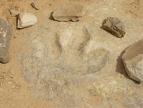
| From Turnoff | From Bridge | Feature |
| 1.6 mi | 7.7 mi | Dinosaur footprint east of road on shelf; parking on west side of road. |
| 2.3 | 7.0 | Pictographs on the east side of road; park south of cattle guard. |
| 4.2 | 5.1 | "Mat Warner" on rock, about 30 feet up on west side of road. |
| 4.7 | 4.6 | Toilet |
| 5.1 | 4.2 | Look for "TKG" bullet holes on southern wall; small but photogenic pictographs close by. |
| 5.6 | 3.7 | Buckhorn pictograph panel, info kiosks, toilet. Major attraction. |
| 9.3 | 0 | Swinging Bridge |
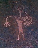 Shooting the petroglyphs
(figures etched into the "desert varnish" patina covering the rock) or
pictographs (figures drawn onto the rock with pigments) is best done in
shade; sidelit panels reveal too much of the underlying
texture, obscuring the figures. The Buckhorn Panel has been "restored",
meaning they have removed all trace of modern man, including Jim Bridger's
name.
Shooting the petroglyphs
(figures etched into the "desert varnish" patina covering the rock) or
pictographs (figures drawn onto the rock with pigments) is best done in
shade; sidelit panels reveal too much of the underlying
texture, obscuring the figures. The Buckhorn Panel has been "restored",
meaning they have removed all trace of modern man, including Jim Bridger's
name.
 The Wash comes out at the San Rafael River, and the swinging bridge put in by
the Civil Conservation Corps in the '30's that remained in use 'till the '80's.
The Bridge Campground is also here, a central location for the northern Swell and
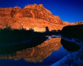
the place I typically camp. In the vicinity of the river are many locations
from which the Wingate cliffs are seen above the river at sunrise or sunset
(best in winter, I think). If you are in the Swell in
the late spring or early summer, you'll find the biting gnats around the river
are particularly pestilent.
The Wash comes out at the San Rafael River, and the swinging bridge put in by
the Civil Conservation Corps in the '30's that remained in use 'till the '80's.
The Bridge Campground is also here, a central location for the northern Swell and
the place I typically camp. In the vicinity of the river are many locations
from which the Wingate cliffs are seen above the river at sunrise or sunset
(best in winter, I think). If you are in the Swell in
the late spring or early summer, you'll find the biting gnats around the river
are particularly pestilent.
Just north of the Bridge is a turnoff (actually a series of turnoffs all going the same place) to Mexican Mountain Road.
Mexican Mountain Road
This road, for me the most photogenic road in the Swell, is also the bendiest road in Utah. There isn't a single straight stretch in its 16-mile (or so) length. Of all the roads in the Swell, it's probably also the road in best condition (except for the ends). It runs from the Bridge down to the Mexican Mountain area.
The road, rutted badly just at the first, passing some soft, gray cliffs of the Moenkopi formation. The surreal look of these cliffs contrasts nicely with the handsome Wingate cliffs above.
 Look for a road to a
river overlook to the west just after the big climb. From this vantage you can
get morning shots of a bend in the river with Assembly Hall Peak (to the
north) or Window Blind peak (south) in the background. By the way, the "blinds"
of Window Blind peak are located on the top, facing northeast. As you proceed
down the road, you'll find many more of these overlooks, but none will be as
easily accessed, and most require as much as a quarter-mile hike. I try to
use flowers, like the primrose, as foreground elements at locations above the
river, and use the river as the mid-ground element in the composition. Other
side roads run to the rivers edge, providing opportunities to contrast the
foreground river and barren cliffs. The morning and evening shots are
problematic when the peaks are far better lit than the river valley; you'll need a 2- or 3-stop ND grad
filter to control the contrast range. River valley shots, are, of course, best when the trees
have greened up, mid-May 'till October. You can get shots of the western cliffs during
winter only; in summer the sun rises over the cliffs.
Look for a road to a
river overlook to the west just after the big climb. From this vantage you can
get morning shots of a bend in the river with Assembly Hall Peak (to the
north) or Window Blind peak (south) in the background. By the way, the "blinds"
of Window Blind peak are located on the top, facing northeast. As you proceed
down the road, you'll find many more of these overlooks, but none will be as
easily accessed, and most require as much as a quarter-mile hike. I try to
use flowers, like the primrose, as foreground elements at locations above the
river, and use the river as the mid-ground element in the composition. Other
side roads run to the rivers edge, providing opportunities to contrast the
foreground river and barren cliffs. The morning and evening shots are
problematic when the peaks are far better lit than the river valley; you'll need a 2- or 3-stop ND grad
filter to control the contrast range. River valley shots, are, of course, best when the trees
have greened up, mid-May 'till October. You can get shots of the western cliffs during
winter only; in summer the sun rises over the cliffs.
In the evening the shots shift to the eastern side of the road when the cliffs are lit up by the sun setting up the valley (the sun moves more northward in summer, and this gives a more dramatic angle on these cliffs). In winter the sun rises along these cliffs and sets right down the Little Grand Canyon.
 Red Canyon is one of the
two hikable, photogenic canyons that penetrate these cliffs. Red Canyon forks,
and the southern fork (to the right) gets the best afternoon light (at least
when I was there in March). White Horse Canyon, farther down the road (beyond
the first gate) is a bit steeper and not as deep. But there is also a short and
fun hike down the hall-like White Horse streambed. Look for some parking in the streambed at the
bottom of a deep wash that leads to some stair step falls. Continue down the
corridor-like canyon for a quarter mile to the big falls (which will be dry if
the canyon is hikable).
Red Canyon is one of the
two hikable, photogenic canyons that penetrate these cliffs. Red Canyon forks,
and the southern fork (to the right) gets the best afternoon light (at least
when I was there in March). White Horse Canyon, farther down the road (beyond
the first gate) is a bit steeper and not as deep. But there is also a short and
fun hike down the hall-like White Horse streambed. Look for some parking in the streambed at the
bottom of a deep wash that leads to some stair step falls. Continue down the
corridor-like canyon for a quarter mile to the big falls (which will be dry if
the canyon is hikable).
 After you pass this draw look for the first of two
trailheads with kiosks. The first is the trailhead for those descending into the
Upper Black Box (or Lockhart Box) part of the San Rafael River. It doesn't hold
as much photographic interest as the second trailhead, which is also intended to
be an access point to the middle of the Upper Black Box, but there is at the
second trailhead a scenic trail worth the effort to hike (map). The scenic trail follows
an old jeep trail for about a mile to
a limestone ridge. If you look down to the west you'll see a flat, then the
river canyon. Look for a trail on the flat heading to the river. It leads to a very
nice overlook down into the Black Box. The climb off the ridge is an easy one,
following the almost stair-step fracturing of the limestone. The name Black Box
comes from the color of the walls, which were originally white to buff in color,
but lichen had darkened them. The flat limestone of the overlook provides
excellent traction, but it is extremely exposed. The edge of the 600 foot drop
is not a place for children or pets.
After you pass this draw look for the first of two
trailheads with kiosks. The first is the trailhead for those descending into the
Upper Black Box (or Lockhart Box) part of the San Rafael River. It doesn't hold
as much photographic interest as the second trailhead, which is also intended to
be an access point to the middle of the Upper Black Box, but there is at the
second trailhead a scenic trail worth the effort to hike (map). The scenic trail follows
an old jeep trail for about a mile to
a limestone ridge. If you look down to the west you'll see a flat, then the
river canyon. Look for a trail on the flat heading to the river. It leads to a very
nice overlook down into the Black Box. The climb off the ridge is an easy one,
following the almost stair-step fracturing of the limestone. The name Black Box
comes from the color of the walls, which were originally white to buff in color,
but lichen had darkened them. The flat limestone of the overlook provides
excellent traction, but it is extremely exposed. The edge of the 600 foot drop
is not a place for children or pets.
As you continue towards Mexican Mountain, you can look back at the symmetrical Window Blind Peak standing out on the limestone floor. As you pass through the second gate, you'll find the road condition takes a turn for the worst as it passes over the ledges. If you are in a passenger car and don't want to attempt it, just north of the second gate is a bench that provides a nice view of the Mountain and it's surroundings. You'll have the road in the foreground, but with a telephoto you can isolate just Mexican Mountain and some aspect of the cliffs surrounding it.
 For
those wanting to continue (passenger cars can make it with careful selection of
your track), you'll find the road ends at the edge of the Mexican Mountain
Wilderness Study Area. About 150 yards back from the big steel gate marking the
edge of the WSA is a parking area. Closer to the mountain you'll need to
go on foot. The scenics here are varied and marvelous. Close in you'll find
some very rugged limestone canyons. There are jeep trails you can follow down
into the canyons, where you'll find more overlooks of the Black Box, and some
whimsical figures created by the erosion of the limestone. The center of
attraction is Mexican Mountain and the cottonwoods on the banks of the river as
it bends most of the way around the Mountain (hence the name Mexican Bend). But
the cliffs surrounding the Bend also provide nice shots when the sun strikes
them at an angle. The base of Mexican Mountain is eroded into a very attractive
series of ridges that show particularly well when side-lit.
For
those wanting to continue (passenger cars can make it with careful selection of
your track), you'll find the road ends at the edge of the Mexican Mountain
Wilderness Study Area. About 150 yards back from the big steel gate marking the
edge of the WSA is a parking area. Closer to the mountain you'll need to
go on foot. The scenics here are varied and marvelous. Close in you'll find
some very rugged limestone canyons. There are jeep trails you can follow down
into the canyons, where you'll find more overlooks of the Black Box, and some
whimsical figures created by the erosion of the limestone. The center of
attraction is Mexican Mountain and the cottonwoods on the banks of the river as
it bends most of the way around the Mountain (hence the name Mexican Bend). But
the cliffs surrounding the Bend also provide nice shots when the sun strikes
them at an angle. The base of Mexican Mountain is eroded into a very attractive
series of ridges that show particularly well when side-lit.
There is a second shot of Mexican Mountain from the cliffs above. To get there you must start at a place called Smith's Cabin, on the eastern side of the San Rafael Reef. It's a bit of a hike up (1500 feet up), but you can position yourself on the edge of the cliffs overlooking the Bend. The third grand view of the mountain is seen from the Jackass Benches, to the southwest (see below).
Cottonwood Draw Road
Cottonwood Draw Road (also called the Buckhorn Wash or Buckhorn Draw Road) connects the Bridge to exit 129 on I-70 and locations southward. It's main function to a photographer is to provide access to other parts of the broad limestone valley of the inner Swell. As in most places in the Swell, interesting shots are found in many locations just off the road. But here I'll concentrate on the major attractions.
Just south of the Bridge is Bottleneck Peak. The trick of shooting it is separating it from the cliffs on the west. Sometimes taking the road west along the river is needed to get a good vantage. The Peak shows it's thinnest aspect from Cottonwood Wash Road. You can also find good shots of Assembly Hall Peak from the tops of the limestone benches south of the Bridge.
For those of you with a 4WD and a sense of adventure there are many two-tracks off Cottonwood Wash Road leading to old mines or test wells, many of which remain open after the February 2003 road orders. Like most places in the Swell, side roads are not marked. I must confess, however, that the views out on these trails is really no different from any you can find right off the road. Often climbing up to the top of a bench changes the vista remarkably, and I think the climbs are worthwhile. Just find some donkey tracks and follow them up.
Sid's Hole, a small reservoir that holds water remarkably late into summer, is 9.3 miles south of the bridge and 5 miles north of the sinkhole. The hole lies at the bottom of a small but photogenic little valley. Morning light flatters it best. This is another fun place for kids.
 The sinkhole mentioned
above is a landmark, but not much of a shot. It's a deposit of gypsum that has
dissolved, leaving a sinkhole. It's surrounded by a circular fence.
The sinkhole mentioned
above is a landmark, but not much of a shot. It's a deposit of gypsum that has
dissolved, leaving a sinkhole. It's surrounded by a circular fence.
To the west of the road is Oil Well Flats (which totally lacks oil wells). This road gives access to the cliffs on the west side of the inner Swell, including the imposing Pinnacles (which I'm told by climbers can be climbed without ropes--I didn't believe them), No Man's Mountain, and the cliffs above Cane Wash. For the really adventurous, a dive down Cane Wash is challenging and fun, but is for 4WD's only.
Cattle is wintered in the Swell. I was there late March 2003 when they were rounded up to transport to the high range. I don't know when they come back down. I'm guessing September.
The Jackass Benches
 In
the southern part of the inner section of the northern half of the Swell (in
other words, just north of I-70), are the Rattlesnake Flats and Benches, and the
Jackass Flats and Benches. The Jackass Benches, because they are the most
eastern situated and provide a grand view of the Mexican Mountain area, are of
most interest to the photographer. I'm willing to say that the view from the
Jackass Benches can rival any other view in the Colorado Plateau. They are named
for the resident but elusive wild burros.
In
the southern part of the inner section of the northern half of the Swell (in
other words, just north of I-70), are the Rattlesnake Flats and Benches, and the
Jackass Flats and Benches. The Jackass Benches, because they are the most
eastern situated and provide a grand view of the Mexican Mountain area, are of
most interest to the photographer. I'm willing to say that the view from the
Jackass Benches can rival any other view in the Colorado Plateau. They are named
for the resident but elusive wild burros.
 The Jackass and Rattlesnake
Benches look much like the Limestone Benches to the north. They are accessed by
passenger car, but to drive right up to a viewpoint you'll need a 4WD or some
hiking. From the bridge, the turnoff is just over a hill 13.5 miles south on
Cottonwood Draw Road. From I-70 (exit 129), it's 5.8 miles north, half mile
north of the sinkhole. Drive 1.7 miles and stay on the left. You'll pass the
road (right) to Black Dragon Wash in 0.2 miles, and another 1.7 miles will take
you to a large fork in the road. This is the start of a loop, and the right-hand
side is the better direction. Passenger cars can navigate this easily. In 3.7
miles is a turnoff to the right that goes up the hill. If you have a 4WD, you
can take it. If not, don't even try. The road leads to the Sulfur Springs
trailhead. This road is interesting because it's
the only road that passes over the top of a bench. And it's from the tops of the
benches that the best views are had.
The Jackass and Rattlesnake
Benches look much like the Limestone Benches to the north. They are accessed by
passenger car, but to drive right up to a viewpoint you'll need a 4WD or some
hiking. From the bridge, the turnoff is just over a hill 13.5 miles south on
Cottonwood Draw Road. From I-70 (exit 129), it's 5.8 miles north, half mile
north of the sinkhole. Drive 1.7 miles and stay on the left. You'll pass the
road (right) to Black Dragon Wash in 0.2 miles, and another 1.7 miles will take
you to a large fork in the road. This is the start of a loop, and the right-hand
side is the better direction. Passenger cars can navigate this easily. In 3.7
miles is a turnoff to the right that goes up the hill. If you have a 4WD, you
can take it. If not, don't even try. The road leads to the Sulfur Springs
trailhead. This road is interesting because it's
the only road that passes over the top of a bench. And it's from the tops of the
benches that the best views are had.
If you travel south just a bit once you are on top you will find a view (up the NE-directed canyon) right next to the road. But if you are willing to walk a half mile or so, parking right at the top of the bench, then walking northeast will take you to the northeast edge where the best views are. You can also travel on down the very rough road (with only one washout) to get a more intimate view of the interior "teeth" of the San Rafael Reef. Note as you walk that the entire bench top is tilted; you are walking on the slope of the 'swell'.
 Another very good viewpoint, and the best
one for those who can't drive up to the right, is to hike up the Bench to the
left (north). If you continue around the loop to the end of the bench, look for
a prominent rock fall at the top (southeast corner) that allows access up the slope to the top. The
best route up is the ridge to the right of the little valley. Again, find some
burro tracks and follow them up. The view from this bench is a little better
than that to the south, as this view includes rugged canyons in the floor of the
Swell as the mid-ground. And as always, the old junipers on the bech tops make
for great foreground elements. I think you can also gain access to the top
of this Bench from the north side, where the trial to Swazy's Leap leaves the
loop. The Benches here are about 600 feet tall, about the same height as the
switchbacks in Bryce's Navajo trail. I'm overweight and out of shape, and the
climb wasn't too bad. Bring water.
Another very good viewpoint, and the best
one for those who can't drive up to the right, is to hike up the Bench to the
left (north). If you continue around the loop to the end of the bench, look for
a prominent rock fall at the top (southeast corner) that allows access up the slope to the top. The
best route up is the ridge to the right of the little valley. Again, find some
burro tracks and follow them up. The view from this bench is a little better
than that to the south, as this view includes rugged canyons in the floor of the
Swell as the mid-ground. And as always, the old junipers on the bech tops make
for great foreground elements. I think you can also gain access to the top
of this Bench from the north side, where the trial to Swazy's Leap leaves the
loop. The Benches here are about 600 feet tall, about the same height as the
switchbacks in Bryce's Navajo trail. I'm overweight and out of shape, and the
climb wasn't too bad. Bring water.
The road to Swazy's Leap, mentioned above, is 4 miles of 4WD road, then a 2 mile walk to the location Sid Swazy is said to have bet his brother that his horse could jump the San Rafael River. There is a sort of bridge there now, an old sheep crossing. Again, there are benches that provide a good view of the Mountain along the road, especially by the trailhead.
On the north side of the loop, about 3 miles north of the fork, is a road to the north (1.7 mi, 4WD) that passes a lone round bench with a good view from on top.
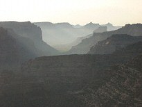
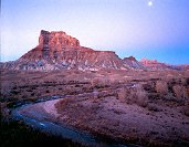
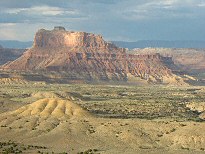
The San Rafael Reef
 The
Reef looks from the east like a series of sloping, triangular teeth. The
bulk of the reef is a layer of white Navajo sandstone, with smaller triangles of
Carmel Formation at the bottom. There is a tourist shot at the rest stop off
I-70, east of the Reef, from the hill just to the north of the parking area.
Better shots (and ones that don't include the freeway in the foreground) are had
by traveling north at the US24 exit. You'll need to find a road leading west to
get out of Buckmaster Draw to a viewpoint of the Reef, with Tidwell draw and the
San Rafael River in the foreground.
The
Reef looks from the east like a series of sloping, triangular teeth. The
bulk of the reef is a layer of white Navajo sandstone, with smaller triangles of
Carmel Formation at the bottom. There is a tourist shot at the rest stop off
I-70, east of the Reef, from the hill just to the north of the parking area.
Better shots (and ones that don't include the freeway in the foreground) are had
by traveling north at the US24 exit. You'll need to find a road leading west to
get out of Buckmaster Draw to a viewpoint of the Reef, with Tidwell draw and the
San Rafael River in the foreground.
Farther north along the Reef is Smiths Cabin, and the trail that leads up the Reef to the Mexican Mountain overlook. You'll need an SUV to get to Smith's Cabin, and strong legs to climb the Reef.
To the south you can take US24 3.3 miles to a road heading west. This road takes you around Shadscale Mesa toward The Squeeze to the north or toward access to smaller canyons to the south.
The most famous location in the northern Reef is Black Dragon Canyon. You get there via westbound I-70, 0.3 miles beyond mile marker 145. Look for a gate off the road to the north. A rough road leads to Black Dragon Wash. In Black Dragon Canyon are several famous, but not particularly photogenic, panels. Many of them have been chalked (the figures outlines with white chalk to show better) which makes them look silly to my eye. Some of the panels are high on the wall.
Head of Sinbad
 The desert south of I-70 is called Sinbad Country. It
looks like the Jackass Bench area, but more eroded. To the northwest side of
Sinbad Country is a small circle of desert surrounded by Navajo sandstone cliffs.
This area is known as the Head of Sinbad. In the Head that
is north of I-70 is a good pictograph panel, and an arch. Getting there requires
a bit of a roundabout drive (indicated on the map) and passage through a small
tunnel under the freeway, but it can easily be done in an SUV, or carefully in
an passenger car.
The desert south of I-70 is called Sinbad Country. It
looks like the Jackass Bench area, but more eroded. To the northwest side of
Sinbad Country is a small circle of desert surrounded by Navajo sandstone cliffs.
This area is known as the Head of Sinbad. In the Head that
is north of I-70 is a good pictograph panel, and an arch. Getting there requires
a bit of a roundabout drive (indicated on the map) and passage through a small
tunnel under the freeway, but it can easily be done in an SUV, or carefully in
an passenger car.
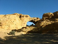 The Dutchman Arch is accessed by the left-hand road as you
exit the tunnel heading north. The arch does not stand up from the rock as
arches do near Moab, but from the back (north) side a shot can be had in the
afternoon (when the brightly-lit rock through the opening will wash out when the
exposure is set for the shadowed arch). In any event, it's a nice place for a
picnic.
The Dutchman Arch is accessed by the left-hand road as you
exit the tunnel heading north. The arch does not stand up from the rock as
arches do near Moab, but from the back (north) side a shot can be had in the
afternoon (when the brightly-lit rock through the opening will wash out when the
exposure is set for the shadowed arch). In any event, it's a nice place for a
picnic.
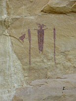
The Head of Sinbad Pictograph panel is a little harder to find. Head back toward the tunnel, and take the road that leads east. Look for a prominent (and worn) road north toward a fence. The fence is protecting the panel. This panel looks (to me) more authentic and interesting than Buckhorn as it has been neither restored nor defaced. There is a second pictograph panel to the east of this one. It's not a particularly interesting panel, as the figures there, found in two groups, are either faded badly or chopped in half when a slab of sandstone fell. The bottom half of the figures there appear cartoonish to me, and must have been quite a contrast to the more stately and abstract figures of the west-ward panel.
The Head of Sinbad is the top of the Swell. Water drains away in all directions.
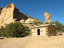 South of I-70, but also in the Head, is Swazy's
Cabin. It's recently been built up as a tourist area (new toilet, parking area,
trail register), but they have removed the fence that used to surround the
cabin, so you might get a morning shot there with the fanciful rock column in
the background.
South of I-70, but also in the Head, is Swazy's
Cabin. It's recently been built up as a tourist area (new toilet, parking area,
trail register), but they have removed the fence that used to surround the
cabin, so you might get a morning shot there with the fanciful rock column in
the background.
Cane Wash/Coal Wash/Devil's Racetrack/Eva Conover Trail
A fascinating series of Jeep/ATV trails wind through the Navajo sandstone canyons in the western reef.
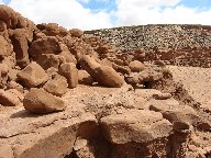
Cane Wash is a dry streambed that most SUV's can navigate. It starts on the north end just past the Calf Mesa Uranium mine (accessed via the second left-hand road south of the Bridge on Cottonwood Wash road). The Wash itself isn't particularly interesting, but it does wind around back of the Pinnacles and along the western cliffs. At the southern end there are three roads out: the SUV road northeast to the Oil Well flats, an Jeep trail southeast to the Head of Sinbad, and the Jeep trail west to the North Coal Wash. The latter is the most interesting and photogenic. This trail, great for ATV's, crosses the rolling hills of the deep red-colored Chinle formation, and occasionally provides views into the interior of the Swell. This trail climbs over Fix-it-pass, then drops into North Fork of Coal Wash. As it does so it crosses a rock fall which requires a bit of skill to navigate.
From Ferron there is a road east that leads to the Coal Wash roads (the North and South forks). These are the only accessible roads in the area, which has Wilderness Study Area designation (thus all other roads are closed). You can drive an SUV through the washes, but to go beyond requires a Jeep or ATV. In North fork is Swasy's Arch, and in South fork is Slipper Arch. You can also see features like Joe and his Dog (Joe lost the bet), Devils Monument, and Devils Racetrack. You really need the BLM Access Map to figure out which roads are permitted, and which are closed. The Fix-it pass is found at the end of North fork, and the Eva Conover road is at the end of the South fork. Fix-it-pass crosses to the south end of Cane Wash, and Eva Conover crosses to the Head of Sinbad area. In North fork is also an ATV trail up to the Devil's Racetrack area (very rugged), and on to the Head of Sinbad.
I have had a wonderful day riding from the Bridge down Cane Wash, then over Fix-it-pass, down North Fork of Coal Wash, do an out-and-back to Devil's Racetrack, then up South fork, Eva Conover, then to the Head, and back to the Bridge via the ATV trail near exit 129 and Oil Flats road. Eight hours and 80 miles of pure fun.
The Red Ledges
 This is a diagonal
outcrop of Carmel formation cliffs topped by Entrada sandstone, a remarkable
landmark. As you start down the road to the Wedge, look for a road south to
Fullers Bottom. This road follows the Red Ledges down to the river, and if you
want to ford the river, continues along the Ledges almost down to I-70. The
Ledges are not particularly photogenic from a distance, where the length of them
belies their height, but a short walk over the desert brings you to the foot of
the cliffs, where you can find many opportunities.
This is a diagonal
outcrop of Carmel formation cliffs topped by Entrada sandstone, a remarkable
landmark. As you start down the road to the Wedge, look for a road south to
Fullers Bottom. This road follows the Red Ledges down to the river, and if you
want to ford the river, continues along the Ledges almost down to I-70. The
Ledges are not particularly photogenic from a distance, where the length of them
belies their height, but a short walk over the desert brings you to the foot of
the cliffs, where you can find many opportunities.
Interesting Locations in the Southern San Rafael Swell
I anticipate that during the next year I can get down to the southern half of the Swell, and report properly on the area. Until then, a short list of the places I've been.
Goblin Valley State Park
Known for it's fanciful goblin-shaped Entrada sandstone hoodoos, this park is always a draw for photographers. The location is east of the reef, and in the San Rafael Desert proper. It's got limited camping, but it's also the only place in the swell that's got water and showers. The road to the Park gives access to the slot canyons listed below, and to the Temple Mountain area inside the Reef.
Little Wild Horse Canyon/Bell Canyon
Very good slot canyons, with better-than-average access. A full loop up LWH and down Bell canyon is about 6 miles long. Little Wild Horse is the better canyon. Other slot canyons in the area, Crack and Chute canyons, have less access and consequently fewer passersby to spoil a shot.
San Rafael Desert/Factory Butte
The Desert, located east of highway 24, is one of the more remote and uninhabited (even by tourists) areas in the US. Factory Butte, south of Goblin Valley, stands tall and strangely "organized" compared to the other eroded buttes nearby. It's named for a factory that once stood in south Provo, Utah (my home town).
Cathedral Valley
This is the north section of Capitol Reef National Park. Most tourists spend time south of highway 24, which divides the park. To the north is Cathedral Valley, a collection of tall and isolated buttes and monoliths in the desert. To get there you drive over the blue Bentonite clay (once a thick layer of volcanic ash from Boulder Mountain big eruption 50 million years ago). At the eastern end of the Valley is the Temple of the Sun and Temple of the Moon, both of which light up remarkably in the first and last light of day.
Tomsich Butte/Red Canyon
A very photogenic drive down the western side of the cliffs in the interior of the southern Swell. This is the southern continuation of the Cottonwood Wash Road.
Nearby Areas of Interest
Manti-LaSal National Forest
To the west of Castle Dale and Huntington is the Manti-LaSal national Forest. I use it as an escape from the desert heat in late spring and summer. Highway 31 and 29 both have campgrounds dotted along their length, but since national Forests have a reservation system, it's sometimes hard to find a spot on the weekend. Along the top ridge of the mountains is Skyline Drive, one of central Utah's best back country drives, providing great views of the Swell to the east.
Nine Mile Canyon
This road, which provides access to many pictograph and petroglyph panels, starts at Wellington, and goes up to the foot of the Uinta Mountains to the north. It takes a day to drive, with sufficient stops to see the panels, and is best done with one of the many Nine Mile Canyon guides (road logs to Native American art, here is the BLM guide). I got several at the well-done Mining and Railroad Museum in Helper (north of Price).
East Carbon City/Sunnyside/Taviputs Plateau
There is a network of 4WD roads in the Taviputs plateau (bounded on the west by the Book Cliffs) that are best accessed via the town of Sunnyside and the Sunnyside Mine.
Cleveland-Lloyd Dinosaur Museum
Just north of Cedar Mountain is a museum explaining and exhibiting many of the dinosaur bones that have been uncovered in the Morrison formation in the Swell.
Environment
Botany
Wildflowers in the Swell are far more abundant than you'd think looking at the place in any season other than Spring. Click here to see some of the wildflowers I've found and tried to identify, mostly in April and May. As for trees, there are only a few. Away from the river there is only Juniper and Pinion Pine. The river is lined by Cottonwoods. I haven't made a study of the rest of the trees there.
Climate
The climate of the Swell is typical of southern Utah deserts. Humidity is always low, so carry drinking water at all times. Summer is hot. Very hot. I try to avoid the place between May and September, when the afternoon temperature is above 95 �F (36 �C). In late Fall and Winter the night-time temperatures are below freezing, but it warms up during the day unless it's December, January or February. Warm fronts in winter or cold front in summer are rare. The late summer skies tend to be cloudless in the morning, giving way to daily afternoon thundclouds, with spring and fall bringing the most interesting clouds to compliment your scenics. Skies in winter are cloudless in the absence of a storm. Currently (2003) there is a severe drought in Utah, so stream crossing is easy. In wetter years the river fords can be impassable and roads can become too muddy to drive for weeks at a time (San Rafael River flow rates). Fortunately, the San Rafael crossings are either bridged or the road through the riverbed is closed.


Geology
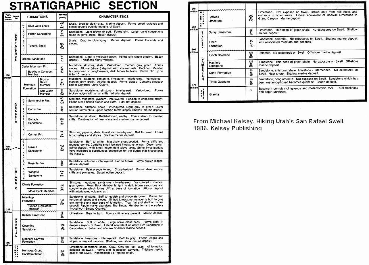
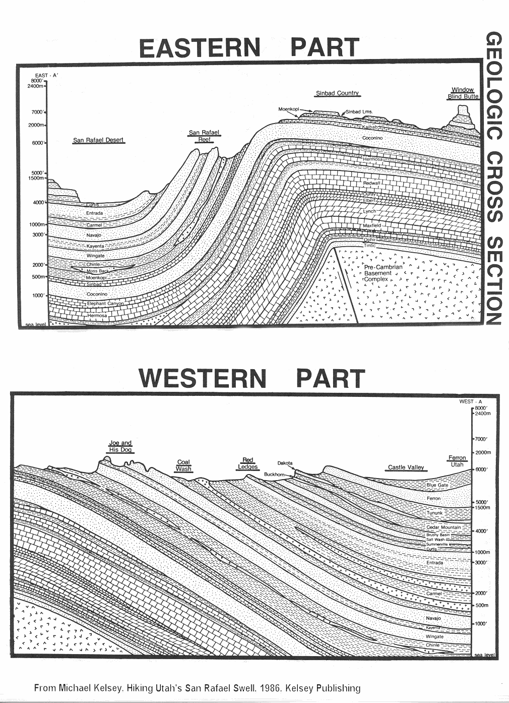
Because the Swell pushed so high, and because it was eroded as it did so, a great part of the stratigraphic column, the sequence of sedimentary layers, is exposed (see the Geological history of Utah and an issue of Surveys with an article about the Swell). In most locations in the interior of the Swell at least six sedimentary layers are visible in the cliff walls. The major part of the Swell is a 30-mile-wide and 60-mile-long bulge ("anticline") pushed up by compression forces 60 million years ago, pushed slowly enough that the three rivers that pass through (Price River far to the north, the San Rafael River in the northern part, and the Dirty Devil River to the south) were not diverted during the upheaval process. In all the interior portion of the Swell is reminiscent of the Circle Cliffs area of the Grand Staircase-Escalante National Monument, but with far more beautiful scenic views and better access to viewpoints. If you have red-blue 3D glasses, look at this 3D map of the Swell (use a red lens over your left eye, and a blue lens over the right. Source.). On the eastern edge is the most vertical part of the Swell, known as the San Rafael Reef (cross section). Aerial views of the southern (source) and northern Reef. Because it's difficult to associate the layers with actual formations, I've included a series of photos with the layers labeled:
Near Mexican Bend
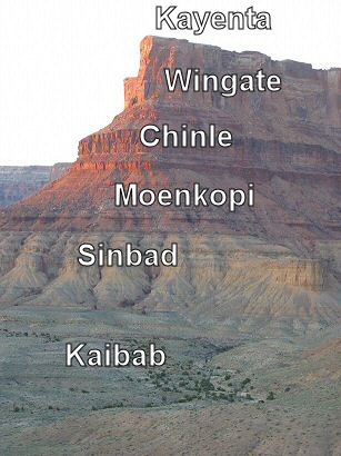
A note about the Chinle (pronounced "chin lee")
formation: in the Swell it
is composed of three members, from top to bottom: the slope of the Church Rock
member, then the cliffs of the Moss Back member (over which the work "Chinle"
above is written), then the slope of the Monitor
Butte/Temple Mountain member. Note that the colorful Petrified Forest member of
the Chinle is not present in the northern Swell. Most mines in the Swell are
located at the bottom of the Moss Back cliffs. The Moenkopi is a ledgy layer, usually thin, below
the broad slope of the Monitor Butte and Temple Mountain members. In the image
above the thin Moenkopi layer actually starts at the bottom of the work "Moenkopi"
and extends downward to the start of the yellow Sinbad layer. The uppermost hard
layer of the Sinbad shows wonderfully-figured ripples, and can be seen as the
stone around the fire pits in the Bridge Campground, or on the mesa tops nearby.
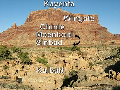
Mexican Mountain
The top of the yellow Sinbad layer is hard, and forms the cap rock of the
Limestone and Jackass Benches. The reddish Moenkopi layer repeats below the
Sinbad in some locations (actually, I think that the Sinbad is considered part
of the Moenkopi group, so some books call it all Moenkopi). The Kaibab limestone is the base of the interior part
of the Swell. The San Rafael cuts all the way through this layer only in the
Black Boxes, where the underlying Coconino sandstone (same layer as the White
Rim sandstone in Canyonlands National Park) is visible.
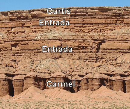
The Red Ledges
The Curtis formation has the appearance of concrete-like conglomerate in
some locations. It protects the Dewey Bridge Member of the Entrada sandstone below from a great deal of
weathering, such that the Entrada forms cliffs, unlike it's companion stone in
Goblin Valley (note that the more famous Entrada sandstone is the Slick Rock
Member, forming the spans in Arches NP). I'm not actually sure the layer I have identified as Carmel is
that, but this is thinly layered soft stone, veined with gypsum deposits, having
the same appearance of the upper part of the Summerville Formation. I think that is it Carmel (similar to the Crystal Creek member?),
but formed into rare cliffs by the protective action of the Curtis. By the way,
both the Entrada and the Curtis are named after locations in the northern San
Rafael Swell. Together the Curtis, Entrada, and Carmel formations are known as
the San Rafael Group. The Navajo formation is covered by the Carmel.
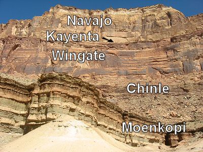
Cliffs above the San Rafael Bridge Campground (actually, down Mexican
Mountain Road a mile)
The Buckhorn Wash and the Little Grand Canyon all show these layers. The
Wedge is topped by some of the Carmel formation also. The Navajo forms rounded
structures, with many cliffs. It is also very cross bedded. Below it is the
Kayenta, a hard sandstone that forms cap rock on many free-standing Wingate
buttes. Here it is a slope-forming layer, which is not quite visible from this
vantage point. Below the Wingate is the ever-present Chinle layer. The
soft cliffs are uppermost part of the Moenkopi, the Moody Canyon member it's
called in Capitol Reef. By the way, this exposure almost mirrors the view of
"The Castle" from the Capitol Reef visitors center. The Navajo,
Kayenta, and Wingate formations comprise the Glen Canyon Group.
The cliffs around the Head of Sinbad are all Navajo. For reasons I don't understand the Cottonwood Wash road, as it goes from the Jackass Benches area to the Head of Sinbad, never seems to go past the cliffs that lie between the Kaibab and the Navajo. I've studied the geological maps, and can't figure it out.
The geology along the Castle Dale road is varied, but marked with signs. Just remember, the signs are standing directly atop the layer they announce. There are several places (the Red Knoll, for example) where you might think the sign is referring to something behind it. It isn't. Take care to note the Cedar Mountain formation and on. That's where the colorful Bentonite-like hills begin. The real color is in the Morrison formation which, like the Chinle, lacks the real colorful layers of the Brushy Basin member seen to the south, but here are still photogenic if you control the sun angle and saturation. By the way, it is in the Morrison formation that the dinosaur bones are found.
West Reef
The western Reef is dominated by the Navajo sandstone layer, best seen from
the Coal Washes and the Eva Conover road. Underlying the Navajo is the Chinle
formation, where the mines are concentrated. From the interior of the Swell you
can see the Navajo, Chinle, and Moenkopi formations. Note that the Wingate and
Kayenta seem to be missing entirely here.
Crypto
Please, please, please remember that if you venture off trail, you are responsible for both your own safety and the safety of the life your are stepping on. The most fundamental form of life in the desert southwest is called microbiotic, or cryptobiotic, soil. It is surface soil stabilized by a symbiotic colony of lichen (which is itself composed of fungus and algae) and bacteria. "Crypto", as it's known, is extraordinarily fragile, and one step will kill it for a decade. But it is the only thing that stabilizes and enriches the soil enough to allow anything else to grow, and must be preserved. If you do venture off trail, make very sure you can recognize patches of crytpo and make every effort to avoid treading on it. The safest plan: walk only on hard rock or in streambeds. Crypto is generally seen as a bumpy, dark patch of soil, but early formations of crypto lack the darker color of the old patches. You'll see crypto at all locations at the same level as the Wedge. I've not seem much below where limestone dominates.
Reference
Books
A short list of the most useful books and reference material concerning the Swell.
Utah's Scenic San Rafael, Owen
McClenahan, 1986, self published.
Mr. McClenahan was a fixture of the area. This is a description of a
series of jeep explorations in the swell, with a lot of history thrown in. Mr.
McClenahan's collection of fluorescent rocks is on display at the Museum of the
San Rafael.
Hiking Utah's San Rafael Swell, Michael R. Kelsey, 1986,
Michael R. Kelsey Publishing.
A description of many hikes in the Swell. Sometimes the descriptions are a bit
wanting, and sometimes he goes places I'm pretty sure would be dangerous for
most of us to follow. His hikes are way faster than I can do them. This book as
a great historical introduction by Dee Anne Finken. Also includes informative
geological cross sections.
Backcountry Adventures
Utah, Peter Massey & Jeanne Wilson (no relation), 2002,
Swagman
Publishing.
This is the guide to driving the backcountry in Utah. Wonderful
descriptions, maps, road logs, and even the history of towns and people of Utah.
A must have if you are driving in Utah's deserts or mountains. The image on the
cover is Mexican Mountain from the Swazy's Leap trail.
Utah Byways,
Tony Huegel, 2000, Wilderness Press.
Another SUV touring book of Utah, but not as big nor detailed as the book above.
I keep this in the glove box. The cover image is Mexican Mountain Road near Red
Canyon.
Photographing the
Southwest, Vol. 1, Laurent Martres, 2002,
PhotoTripUSA.
Wonderful book on the Colorado Plateau. Includes a chapter on the Swell. Part of
a series.
Utah Road & Recreation Atlas, 2002,
Benchmark Maps.
Useless for desert navigation, but good for figuring out what you see
from a high viewpoint, and for driving the paved roads.
Desert Solitaire,
Edward Abbey, 1968,
Balantine
Books
I first went to the Swell to find a place that is like Arches as
Abbey describes it before it was paved and made a park.
National Audubon
Society Field Guide to North American Wildflowers, Western region, revised
ed., Richard Spellenberg, 2001, Chanticlear Press.
A great guide to the wildflowers abundant in May.
Geology of Utah's Parks
and Monuments, Douglas A. Sprinkel, Sr. Ed., 2000, Utah Geological
Association, Publication 28.
An outstanding reference volume on the geology of the national and state parks
in Utah. It does not, however, have a chapter on the Swell. There is enough
information on other parks (pay particular attention to the chapters on Capitol
Reef and Goblin Valley) to figure out the Swell geology.
Maps
National Geographic/Trails Illustrated San Rafael Swell, Map 712.
TOPO! v3.3 Utah State Software,
National Geographic.
San Rafael Motorized Route Designations, February 2003,
BLM Price.
Links
SanRafaelSwell.org
Run by a high-school buddy of mine, information and images of the entire Swell.
Emery County San
Rafael Swell Castle Country
Self-guided tour of the San Rafael Swell
Emery County, Utah
Hike Index
San
Rafael Swell
San Rafael Swell 4WD Trails
San Rafael Swell and
Goblin Valley State Park
San Rafael Swell Study Utah
Bureau of Land Management
SAN RAFAEL SWELL WILDERNESS
The
Geology of the San Rafael Swell
Tom's Utah
Canyoneering Guide - San Rafael Swell
Utah Rock Art Sites
Sinbad Desert Amateur Radio Club
San
Rafael Swell Geology-BLM